Seychelles Seagrass Mapping and Carbon Assessment Project
Meet the team who have been working on the fieldwork and blue carbon numbers for Seychelles’ seagrass meadows.
Name: Dr. Gwilym Rowlands
Project role: Principal Investigator / Earth Observation Scientist
Dr. Rowlands research examines how earth observation data, such as satellite imagery, can be best harnessed to the needs of ecology, conservation, and management. This work includes image and spatial analysis, field monitoring and survey, as well as mathematical modelling to quantify and conserve marine habitats, estimate marine carbon stocks (Blue Carbon), as well as fisheries applications. His work spans tropical and temperate regions of the world, in coastal and oceanic settings and draws on satellite, airborne and vessel-borne sensors.
 Name: Lucy Martin
Project Role: Geospatial data management/ Fieldwork planning
Lucy is the Research Assistant at Oxford University. Her research harmonises marine geospatial data management with innovative field research methods and seeks to collaborate across multiple sectors to benefit the environment and local communities. Her background spans marine ecological fieldwork in tropical and temperate locations as well as data management to inform government policies that drive marine resource management.

Name: Dr. Dimosthenis Traganos
Title: Project Manager in the German Aerospace Agency (DLR)
Project role: DLR Lead Scientist for the Coastal Aquatic Earth Observation Analysis
Dr Traganos manages the R&D within the Global Seagrass Watch technology transfer project of DLR. This work merges modern Earth Observation advances with artificial intelligence, ecological modelling, and field data to enhance spatially-explicit knowledge and insights pertinent to global nature-based solutions like seagrass ecosystems. His expertise lies in the development of monitoring algorithms for temperate and tropical coastal ecosystems from coastline to bioregional scale, with the aid of active and passive remote sensing, marine geophysics, oceanography, and in situ data.
 Name: Dr Stacy Baez
Title: Senior Officer
Dr. Baez manages the research portfolio for Pew’s Protecting Coastal Wetlands and Coral Reefs Project. She supports countries in developing the scientific framework needed to ensure strong protections for coastal wetlands and coral reefs within nationally determined contributions.
 Name: Dr Jeanne A. Mortimer
Project Role: National Focal Point for the Seychelles Seagrass Mapping and Carbon Project
Dr. Mortimer is an international conservation biologist consultant focusing on sea turtles and tropical coastal and marine ecosystems. She has lived and worked in the outer islands for extended periods totalling several years which enabled her to visit virtually every island in the archipelago. Her primary interests are ecosystem conservation in Seychelles and the wider Western Indian Ocean, and the biology of sea turtles, giant tortoises, and seagrass habitats.
 Name: Pierre-André Adam

Title: Head of Science and Projects
Project Role: Island Conservation Seychelles’ Focal Point
Pierre-André is responsible for administrating the development and implementation of conservation projects and programmes for Island Conservation Seychelles. He has a particular interest in the ecology of coral reefs and associated ecosystems, biogeography, and life history strategies of corals, coral diseases, bleaching and resilience in corals,
 Name: Dr. Jerome Harlay
Title: Senior Lecturer at the University of Seychelles in the BSc. Environment and the MSc. Marine Science and Sustainability.
Project role: Data Scientist and Marine Operations for BERI
Professor Harlay’s research explores the biological, physical and geological processes and reactions that connect the biotic and abiotic world. His scientific expertise is pertinent to assess the vulnerability of marine ecosystems to climate change, with a specific focus on ocean acidification (SDG 14.3), and warming, to study nature-based adaptation and mitigation options and to communicate science-based information.
Picture credits: James Gifford, IORA Blue Carbon workshop, Perth 2018.
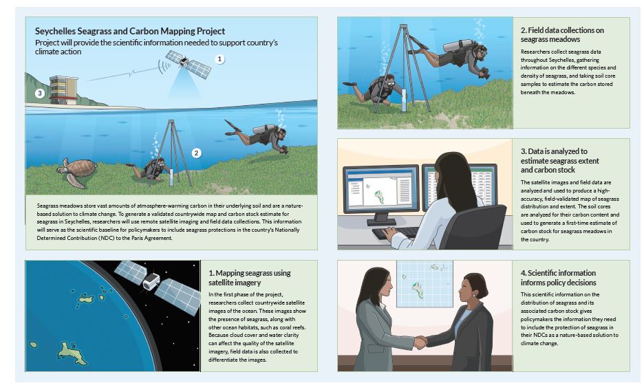
How will we accomplish the Seagrass meadows mapping and carbon data?